
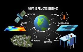
Remote sensing is the science of collecting information about the Earth’s surface without direct contact, using satellites, drones and aircraft mounted sensors. it works by detecting electromagnetic radiation(light) reflected or emitted by objects on earth. Humans see only visible light, but satellites can detect infrared, shortwave infrared, microwaves/radio waves, gravitational and magnetic variations. each material reflects energy differently as this unique reflection pattern is called a spectral signature (like a fingerprint).
Background
There are two ways sensors see the world that is:
- Passive Sensing: These sensors are like a standard camera. They wait for natural energy (like sunlight) to bounce off the Earth. If there is no sun (at night), they can’t “see” unless they are looking for heat (thermal).
- Active Sensing: These sensors provide their own light source. For example, a Radar system sends out a pulse of energy and measures how long it takes to bounce back. Because they bring their own “flashlight,” they can see through clouds and work in total darkness.
- The process generally follows these steps:
- An Energy Source: Usually the Sun, which provides light.
- Interaction: Sunlight hits an object (like a forest or a lake).
- Reflectance: The object reflects some of that light back up toward the sky.
- The Sensor: A satellite or drone captures this reflected light.
- Data Processing: This captured data is sent to a computer on the ground and turned into an image or a map.
Importance
Remote sensing allows us to see the “big picture” that is impossible to view from the ground.
- Agriculture: Farmers use satellite images to see which parts of their fields are thirsty or need more fertilizer long before the plants actually start to wilt.
- Disaster Management: After a flood or earthquake, satellites provide instant maps of the damage, helping rescue teams find where help is needed most.
- Weather Forecasting: Every time you check a weather app, you are looking at remote sensing data. It tracks clouds, storms, and rising ocean temperatures.
- Climate Change: Scientists use it to monitor how fast glaciers are melting or how much of the Amazon rainforest is being lost each year.
Key Index: NDVI
- NDVI (normailzed difference vegetation index) compares red light absorption and near infrared reflection.
- High NDVI indicates healthy vegetation.
- Low NDVI indicates stressed, diseased, or water deficient plants.
Healthy plants contain chlorophyll. it absorbs red light (for photosynthesis) and reflects near infrared light (for avoid overhead light).