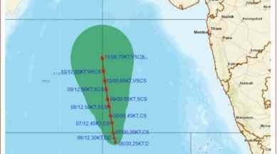
According to the India Meteorological Department (IMD), Cyclone Biparjoy is expected to move northwards towards Pakistan, alleviating concerns of its impact on India’s west coast. However, the formation of the cyclone in the Arabian Sea and its subsequent movement could affect the onset of the southwest monsoon over Kerala.
The existing system rapidly intensified from a cyclonic circulation to a low-pressure area on Monday evening and further strengthened into a depression over the southeast Arabian Sea by Tuesday morning. Currently located southwest of Goa, it is predicted to head towards Pakistan without affecting India’s west coast, as per the cyclone track forecast.
IMD’s latest updates indicate that the system is likely to intensify into a cyclonic storm over the east-central Arabian Sea and adjoining southeast Arabian Sea within the next 24 hours. Once it attains storm status, it will be named Cyclone Biparjoy by Bangladesh.
This will be the second cyclone to form within three weeks in the North Indian Ocean, following Cyclone Mocha in the Bay of Bengal, which caused significant damage in Bangladesh and Myanmar.
Despite favorable conditions for the monsoon’s progress, including cloud formations off the Kerala coast and strengthening monsoon winds, the onset over mainland India has been delayed. The IMD officials attribute this delay to the inadequate land heating during the summer season, as fewer heatwaves were recorded due to rainfall influenced by western disturbances.
While the normal onset date for the monsoon over Kerala is June 1, the IMD had predicted a likely onset on June 4 with a standard deviation of four days. The development of a cyclone could further hamper the progress of the monsoon.
The monsoon onset data from the IMD reveals that the most delayed onset over Kerala since 2005 was on June 8.
As the situation unfolds, uncertainties remain regarding the impact of Cyclone Biparjoy on the monsoon onset, and its progression will continue to be closely monitored by meteorological authorities.


